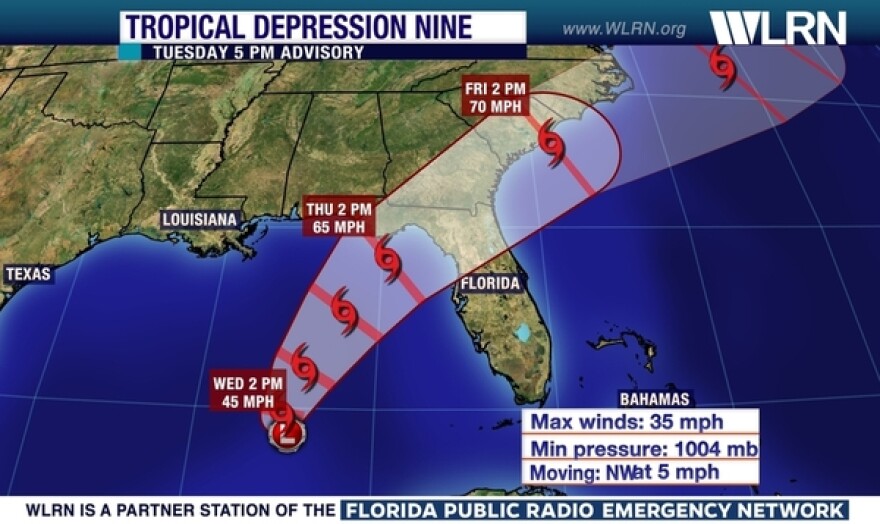
Even though Tropical Depression Nine hasn’t officially become a Tropical Storm yet, a Hurricane Watch was issued for Florida’s Gulf coast from Anclote River to Indian Pass. A Tropical Storm Watch is also in effect west of Indian Pass to the Walton/Bay County line.
National Hurricane Center Director Dr. Rick Knabb urged those living along the coast to be prepared for the worst.
“We want people to focus on NOT what it is now, but what it could be. The forecast is for a tropical storm, but it could also become a hurricane.”
Further inland, Tropical Storm Watches were also issued by the National Weather Service for Tallahassee and surrounding areas, along with counties along Florida’s Nature Coast.

Still a Depression
The tropical depression lacked sufficient organization to be classified as a tropical storm late Tuesday afternoon, according to the most recent data from NOAA’s Hurricane Hunters. However, new forecast data continues to suggest that there will be a window of opportunity for intensification in the next 24 to 36 hours prior to landfall.
The Track
Confidence is high that the soon-to-be tropical storm will turn north and accelerate northeast toward North Florida Wednesday. The storm’s center could then come ashore anywhere between Panama City and New Port Richey on Thursday. Near and to the right (or southeast) of the storm’s track is where the greatest wind and water hazards will be, which could include storm surge, wind damage, and coastal flooding. Other hazards such as inland flooding, rip currents, and tornadoes may occur hundreds of miles from where the storm comes ashore.
How Strong
While conditions are somewhat favorable for strengthening Wednesday, challenges arrive Thursday. Drier air sitting to the northwest of the storm and fast winds aloft moving in from the northwest are both likely to play a role before landfall. The stronger the storm becomes before these negative factors take hold, the more likely it is to maintain its intensity. If the storm is not able to strengthen or organize sufficiently, the aforementioned conditions may cause some weakening prior to landfall.
The difference between a strong tropical storm with winds of 65 mph (as forecast) versus a Category 1 Hurricane will be most pronounced along the coast, where storm surge and coastal flooding could be significant if the system becomes a hurricane. The shallow nature and low terrain of the Nature Coast and Big Bend makes these areas especially prone to storm surge inundation. Further inland, heavy rain, flooding and minor wind damage will be possible no matter how strong the storm could be at landfall.


