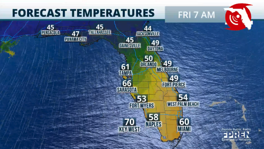
A strong, cold front will bring the coolest air of the season so far across the Sunshine State this week. Before the cold air moves in, the entire peninsula must deal with strong to severe thunderstorms. Not everyone will deal with severe thunderstorms, but much of the state will have rain as the front sweeps south.
The cold front will approach North Florida on Tuesday. Expect Tuesday to be active, with the highest risk of severe thunderstorms across this region. The strong to severe thunderstorms will mainly affect the afternoon. The storm's greatest threat is the risk of tornadoes developing mainly south of the I-10 corridor and west of Tallahassee. There’s also the chance for flash flooding, as there will be deep moisture, courtesy of Sara’s remnants being absorbed by the cold front. Showers and thunderstorms will be moving from north to south, and by Tuesday night into the early morning on Wednesday, they should be coming over to Central Florida. South Florida can expect a mostly cloudy Wednesday with warmer temperatures due to the winds being from the south just before the cold front moves through late afternoon.

This cold front will lose its deeper moisture as it travels southward and over Florida. There could still be a few scattered showers and thunderstorms, but these will be more isolated in nature. Rainfall totals will be the highest across the western portion of the Panhandle, where there could be some areas with 3 to 5 inches of rain, while Central Florida will stay with about 1 inch of rain. There will be slightly higher amounts across the Tampa Bay area. South Florida could see some isolated spots with 1 inch of rain.

Biggest temperature drop of the season so far
Temperatures will drop across the entire Peninsula. For much of the state, these are the coolest temperatures since February. The coldest morning will be Friday morning, with portions of the Panhandle having temperatures around sunrise in the upper 30s for rural areas. In comparison, North Florida and rural areas of Central Florida will wake up to the 40s. Orlando will likely stay around 50 degrees. South Florida will have temperatures in the mid-50s inland and metro areas in the upper-50s to low 60s.

Very dry air will take over, and winds from the north will guarantee that the skies will remain mostly blue on Friday. A reinforcing front will sweep through on Friday, carrying blue skies, dry conditions, and cooler temperatures into early next week.


