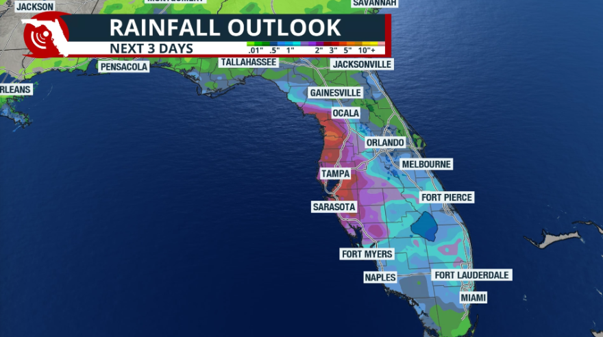
With the location of a stationary front draped from northern Florida and attached to a low-pressure system over the Southeast, there is plenty of rising air and instability available in place. The wind is bringing lots of moisture from the Gulf, which is aiding the storm production across Florida.

It's been a very wet Saturday for most of the state, especially over the Peninsula. Although official weather gauges have accumulated over 4 inches in the last 3 days, mainly over the west coast, there has been over 2 inches of rain that has fallen on Saturday in places over Southwest Florida like Lehigh Acres and Cape Coral. Lake Shore Estates in the Tampa Bay area has received over 1.5 inches since midnight, and the rain continues to fall. In Southeast Florida, Boynton Beach and Tamarac have stayed with just under one inch, and Miami Lakes and Pembroke Pines east are also just under an inch in less than 24 hours.
Sunday is likely to continue very wet. The same pattern will remain in place at least through Monday afternoon. The stationary front will finally get moving and exit through the Jacksonville area. For Sunday, with the ground already well saturated from the recent rains, flooding could develop more easily. Please stay away from flooded roads. Remember, turn around, don't drown. Even frequently traveled roads could have deeper waters than expected.
Remember that there will also be plenty of thunderstorms. If you hear thunder, go to a safe place.

The main flow will be from the west. So the storms and showers will continue to enter from the Gulf, move through the Peninsula, and exit over the East Coast of Florida. Through Tuesday, the heaviest rainfall is expected to be confined to west Central Florida. There will be another front entering the state early next week and becoming stationary, draping over the area as it loses its speed, so there will be more instability laser-focused over Central Florida. For South Florida, there will be moisture still in place, and the rain showers are hopefully putting a big dent in the drought that continues to be in place over Southeast Florida.
The Panhandle and parts of North Florida could experience a touch of drier air and perhaps lower humidity levels. As the cold front pushes over the Southeast, it could have enough strength to drop the dew point, limiting shower activity and making the temperatures more comfortable. Don't get too excited about a cooldown, but you will definitely feel lower, more refreshing humidity levels by Thursday afternoon.


