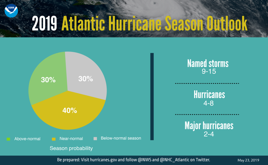
Hurricane forecasters on Thursday called for a near normal Atlantic season this year following three brutal years that produced hurricanes Maria, Irma, Harvey, Florence and Michael.
Forecasters said a weak El Niño is competing with ongoing warm Atlantic waters fueling West African monsoons - where many hurricanes are born. The dueling conditions are expected to generate nine to 15 named storms, four to eight hurricanes and two to four major Category 3 storms with sustained winds topping 111 mph. An average season produces about 12 named storms, six hurricanes and three major storms.
Forecaster Gerry Bell said NOAA, the National Oceanic and Atmospheric Administration, is predicting a slightly higher number of storms than earlier forecasts, including a statistical model produced by Colorado State University, because of the weakening El Niño.
El Niño weather patterns in the Pacific can help tamp down Atlantic storms because they generate high upper atmospheric winds that slow towering hurricane winds.
"It's these competing factors," Bell said during a press briefing. "That's still a lot of activity. Nine to 15 named storms is lot."

A decades-long weather pattern that produces the warmer ocean waters in the Altantic, known as the Multidecadal Oscillaiton, or AMO, is also showing no signs of fading, Bell said. The warm waters feed the monsoons off the West African coast, where many hurricane originate, and continue to fuel storms as they churn west. Historical records dating back to the 1800s show the pattern tends to last between 25 and 45 years.
There's no way to predict when that pattern will end, he said.
Forecast models have increasingly produced more accurate tracks but continue to struggle with predicting wind speeds. A new model that is being tested this year could help improve them.
"We're optimistic that this year forecast skill will be upgraded," acting NOAA administrator Neil Jacobs said.
The Federal Emergency Management Administration, which has come under criticism for its slow response to disastrous storms, is also better positioned this year, said acting FEMA director Daniel Kaniewski.
"Those personnel are now predeployed to those areas most that are most likely to be impacted," he said.
The preseason forecast has about a 70 percent chance of occurring, based on past forecast success over the last decade, Bell said. The forecast will be updated later in the season when the number and intensity of storms picks up in mid August.


