Weather Updates
-
 Just days after strong storms and numerous tornadoes across the Panhandle, the risk for severe thunderstorms returns
 -
 A severe weather system tracked across the Southeast this morning, and it spawned reports of tornadoes and damaging wind gusts across Florida’s Panhandle.
 -
 A severe weather system tracked across the Southeast this morning, and it spawned reports of tornadoes and damaging wind gusts across Florida’s Panhandle.
 -
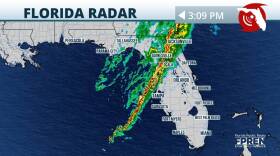
 The same system that produced damaging winds and tornado reports is entering the Florida peninsula this afternoon. Impacts to continue into the evening.
 -
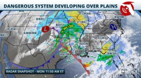 Multiple rounds of dangerous thunderstorms are expected as another strong winter storm barrels across the country. Damaging winds and a few tornadoes (potentially strong) are possible, especially over the Panhandle and North Florida.
 -
 While Florida is known for its generally mild winters compared to many other parts of the country, winter weather, including sub-freezing temperatures, freezing rain, and even snow, are possible over parts of the state.
 -
 Floridians may not be wearing mittens and scarfs this Christmas. A frontal system moving through will increase chances for showers and thunderstorms on Sunday and Monday for much of the state.
 -
 It’s beginning to look at lot like ... hurricane season. At least that's the case across much of South Florida, where it’s been windy and rainy for two days and the forecast predicts more of the same this busy holiday season weekend.
 -
 Strong winds and 3-5 inches of rainfall are possible across most of the state this weekend. Before the main storm arrives, conditions to remain windy on Friday.
 -
 Weather patterns are changing entering the winter season, and this could continue to bring wetter conditions to the Southeast.


