-
 In Florida, hurricane vulnerability is shaped not just by the storm, but by the way people live — in high-rises, along waterways, and across coastal communities where power loss, heat, and marine damage can complicate recovery.
 -
 City of SarasotaSaharan dust and wind shear are keeping things quieter in the Gulf, but an ocean scientist says, "it only takes one in the wrong place."


-
 The Peninsula had drier-than-usual conditions as Bertha was west of the state. The wind also left less hot afternoons across the western portion of the Peninsula, but as we wave goodbye to Bertha, rain and heat return to Florida. Let's look at this week's forecast.
 -
 Tropical Storm Bertha is producing dangerous surf and life-threatening rip currents for beaches along Florida's Panhandle.
 -
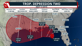 Tropical Depression 2 is set to become Tropical Storm Bertha as it travels mainly due west during the next few days. Gulf waters are warm and could strengthen this system if it stays well away from the Gulf Coast.
 -
 Rounds of heavy rain will impact parts of Central and North Florida due to a potential tropical system. Mixed signals on where it could go and intensity.
 -
 Florida's meteorological summer is at its halfway point. So far, the 2026 season has produced above-average warmth and varying amounts of precipitation.
 -
 Heat doesn't just make you sweat—it can affect your brain, your sleep, your decision-making, and even become deadly long before many people realize they're in trouble. Here are five more hidden heat dangers every Floridian should know.
 -
 Florida citrus production finished the 2025-26 season slightly above initial forecasts. Despite the output, production remains near historic lows.
 -
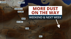 Saharan dust is in place, and a high pressure will continue to bring dangerous heat across much of Florida throughout the weekend.
 -
 A strengthening El Niño over the Pacific Ocean may be already influencing Florida's weather, with long-range outlooks indicating a return to below-average rainfall.
 -
 Colorado State University released their updated predictions for the 2026 hurricane season. However, they expect even fewer named storms compared to their last forecast in June.


