
As with any other major holiday, Florida is also a popular Thanksgiving destination. The weather will be rough on Thanksgiving in South Florida, where storms are possible. Still, the northern half will experience a turn in temperatures, with cooler conditions by evening, and a windy, dry, and cooler Black Friday for all. Good weather for the northern half to see everything Florida has to offer, or to lie around with family and friends and enjoy the outdoors.
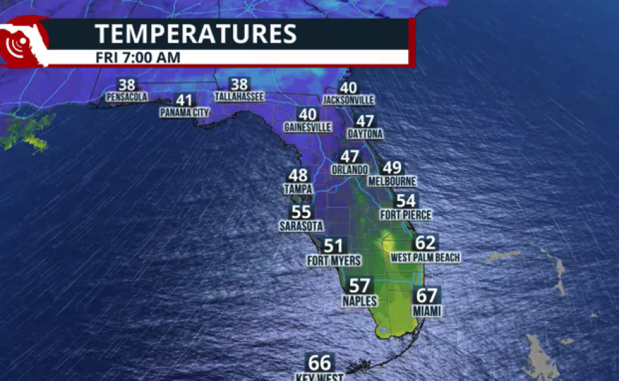
Between Wednesday and late Thursday, a cold front will push through Florida. While Thanksgiving Day will be cooler for the northern half, South Florida residents and visitors should stay weather-aware. There will be showers, a few storms & less warm temperatures.😬 pic.twitter.com/rv6rBnMD7W
— Florida Public Radio Emergency Network (FPREN) (@FloridaStorms) November 26, 2025
Forecast for North Florida and the Panhandle.
A cold front is pushing through North Florida on Tuesday night through Wednesday afternoon. This cold front could bring a chance for some passing showers and scattered thunderstorms throughout the afternoon on Wednesday. As the cold front continues to push south, very dry air will arrive in the northern portion of the state. The winds will pick up starting Wednesday evening and come from the north, keeping temperatures on a steady downward slope as the dry air arrives. Gusts could reach 20 mph on Thanksgiving Day and slowly subside starting Friday.
The tire light sensor might turn on during the Thanksgiving holiday; it's likely the weather!
Expect the dry air to take over just in time for Thanksgiving and continue to reign throughout the holiday weekend. This dry air mass is strong. Forecast dewpoint temperatures, which indicate the amount of water available in the atmosphere, will be extremely low, with the lowest values likely to be recorded early Sunday morning before they start rising again. Tallahassee is forecasting a dewpoint temperature of 19°F. This is bone-dry air that will suppress showers and thunderstorms for many days.


Of course, along the I-10 corridor, there is a lingering, worsening severe drought, which, combined with bone-dry air and breezy conditions, creates a dangerous combination and is very bad for wildfires. During this week and throughout the weekend, please avoid any activities that might spark. Any fires that get started could quickly become erratic under these conditions.
Wildfires, fire bans, and a worsening drought across parts of Florida
Forecast for Central Florida.
The cold front will push through Central Florida between Wednesday night and Thursday morning. There’s a slight chance for an isolated passing thunderstorm, but overall, there will be passing showers through this period. Highs will be in the mid-80s on Wednesday afternoon, but struggle to reach the upper 60s on Black Friday. The dry air will also persist through much of the weekend, suppressing any chances of showers and thunderstorms. A gradual increase in humidity values starting Sunday, but still dry, as the winds shift. Many areas across Central Florida continued to have burn bans in effect, so please avoid any activities that involve fires or sparks.


Southeast Florida will be the exception, not the rule.
South Florida will be the most affected by showers and even a few more thunderstorms in the afternoon on Thanksgiving Day. There will still be plenty of heat available on Thursday afternoon across South Florida to ignite more thunderstorms than the atmosphere can handle on Wednesday across Central Florida. Also, the front will be passing my area as the day loses its peak heating across Central Florida. Also, while the front pushes through South Florida, it will become weaker, so don't expect a significant cooldown. Temperatures will feel a tad more comfortable on Friday night, and humidity will be less noticeable, but the cold air will not reach as far south. Highs on Friday will be in the low 80s, and temperatures are likely to bounce back the fastest by the weekend, into the mid-80s, as winds change and humidity gradually creeps up.


