-
 In Florida, the forecast cone is only part of the story. Hurricane impacts can extend far beyond the center track — reaching inland through wind, flooding, and tornadoes.
 -
 About two-thirds of the U.S. is in some stage of drought in late spring 2026, yet at the same time the country has been seeing more intense downpours. It might seem contradictory, but both are symptoms of rising global temperatures. The reason has to do with the water cycle.
 -
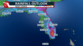 Days of rain across Florida as tropical moisture arrives and increases the flood threat.
 -
 Hurricane Melissa grew into one of the most powerful Atlantic tropical cyclones in recorded history on Oct. 28, 2025, hitting western Jamaica with 185 mph sustained winds. The Category 5 hurricane blew roofs off buildings and knocked down power lines, its torrential rainfall generated mudslides and flash flooding, and its storm surge inundated coastal areas.
 -
 Climavision, a weather technology company, plans to install at least four new radar systems across the state, which will help improve detection of precipitation. The National Weather Service operates long-range Doppler radar systems across Florida, with sites in Tampa, Key West, Miami and Melbourne, Jacksonville, Tallahassee and Eglin Air Force Base in the Panhandle.
 -
 South Florida doesn’t need reminders of what rising seas can do. Streets flood on sunny days, businesses brace for storm surges, and municipalities are under pressure to plan for a future where the waterline keeps creeping higher.
 -
 Katrina wasn’t the first hurricane to hit the city, and won’t be the last. Here’s what’s different now.
 -
 Underwater currents in the Gulf should be monitored when a hurricane approaches Florida. A new study shows the current slowed just before Hurricane Ian turned into a monster Category 5 storm in 2022.
 -
 On "The Florida Roundup," Tom Hudson spoke with Florida Public Radio Emergency Network chief meteorologist Tim Miller about the federal government's role in weather forecasting and communicating dangers.
 -
 El Nino contributed to Florida's cool winter, La Nina to arrive by summer and could influence hurricane season.
 -
 Damaging wind gusts, heavy rain and stray tornadoes are possible from another round of thunderstorms expected to traverse Florida. The threat arises from a developing weather system that will dip into the Gulf Coast early Tuesday.
 -
 The National Weather Service teaches hundreds of people every year on how to identify specific weather events through its free storm spotting class.
© 2026 WLRN
Play Live Radio
Next Up:
0:00
0:00
Available On Air Stations


