-
 A stationary front increases rain coverage across parts of Florida through the end of this week, while a high-pressure system builds just in time for the weekend, bringing temperatures near record heat or breaking records.
 -
 While a rare cold front will bring drier air across the northern half of the state, rain could meander across South Florida for the weekend, and winds bring hazardous conditions along the beaches.
 -
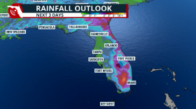 Days of rain across Florida as tropical moisture arrives and increases the flood threat.
 -
 The tornado had peak winds of 85 mph, and it traveled over half a mile across northern Miami-Dade County.
 -
 Get ready to peel-off layers! We will bounce back to slightly above-average temperatures
 -
 Water levels in the Biscayne Aquifer have fallen dramatically... and there are still close to 4 months left of the dry season.
 -
 Much-welcomed rain continues to fall across South Florida, but we await a stronger cold front that will sweep over the state on Thursday and could possibly bring the coldest air mass of the season so far.
 -
 Exceptional drought is erased from the Panhandle after days of rain, but the rains that fell across South Florida didn't do much, and a moderate drought now inches closer to parts of Metro South Florida
 -
 Florida's fog season typically runs from late fall through the early spring due to the combination of moisture around and cooler air temperatures.
 -
 Rain coverage will increase from north to south as a front and then a storm moves through the South.
 -
 A Gulf Low and a Caribbean system will simultaneously impact Florida this week. Flooding winds and damaging wind gusts are expected over the Panhandle and South Florida
 -
 The National Hurricane Center is closely monitoring an area in the Gulf of Mexico that promises to bring heavy rain and gusty winds to Florida by the end of the week.
© 2026 WLRN
Play Live Radio
Next Up:
0:00
0:00
Available On Air Stations


