

Despite the numerous showers, thunderstorms, and channels of tropical moisture that have lingered across many parts of Florida over the last few days, drought conditions continue. Currently, only 3% of the state is not experiencing some level of drought. That means 97% of Florida remains under drought conditions, with about 14% of the state in extreme drought and 52% in moderate drought.
The drought map tells part of the story, but all of Florida's major official weather stations are recording rainfall deficits of several inches during the first seven months of the year, including at least two months of the rainy season. Even more astonishing is that June and July are typically the two wettest months of the year for many locations.
When we go back to the beginning of the 2025 dry season, several locations were already running below average in rainfall. We then moved through one of the worst droughts in Florida's history. The weather remained exceptionally dry, and the beginning of this summer has also been much drier than average across many parts of the state. Take a look at how year-to-date rainfall compares to average rainfall across 10 official weather stations in Florida.
Chart below: Rainfall across several official stations in Florida. All stations show a rain deficit since the start of 2026 until July 31.
City | Average year-to-date rainfall (inches) | Actual year-to-date (Jan 1 - July 31)(inches) |
| Pensacola | 39.95 | 30.09 |
| Tallahassee | 35.99 | 23.52 |
| Jacksonville | 30.37 | 23.68 |
| Gainesville | 38.72 | 17.71 |
| Daytona Beach | 27.77 | 24.58 |
| Orlando | 29.93 | 14.12 |
| Tampa | 28.35 | 21.56 |
| Fort Myers | 31.52 | 22.78 |
| West Palm Beach | 32.35 | 31.14 |
| Miami | 34.28 | 22.77 |
Orlando is experiencing its second-driest year-to-date since records began in 1892. Fort Lauderdale is seeing its fifth-driest year-to-date, with a rainfall deficit of just over 8.5 inches since January 1, 2026. Miami has accumulated nearly 23 inches of rain this year, compared to its average year-to-date rainfall of 34.28 inches. That leaves Miami with its 14th-driest year-to-date on record.
Southwest Florida is not far behind. Naples Municipal Airport, the city's official weather station, is running about 4 inches below average for the year, marking its seventh-driest year-to-date. The Gainesville area is also experiencing very dry conditions, with a rainfall deficit of nearly 11 inches. This ranks as its third-driest year-to-date on record.

Jacksonville is also dealing with a significant rainfall deficit, with many surrounding areas still under severe drought conditions. The city is experiencing its ninth-driest year-to-date based on the period of record at its official weather station. The Tallahassee area would need nearly a foot of rain just to return to average year-to-date rainfall. The city is currently experiencing its 17th-driest year-to-date on record. Although Pensacola would need about 9 inches of rain to reach its average year-to-date rainfall, it remains in a rainfall deficit. Based on 147 years of records, Pensacola is experiencing its 36th-driest year-to-date.
Has the heat contributed to the drought?
The heat has certainly played a role by increasing evaporation and drying out soils and vegetation even faster. But it works both ways—when rainfall is below average, there are usually fewer clouds, allowing more sunshine to heat the ground. That creates a cycle where dry conditions fuel hotter temperatures, and hotter temperatures lead to even more drying. There are several ways to measure how this year's heat has ranked across Florida. In South Florida, especially across Southeast Florida, the persistent heat has left many official weather stations—including Fort Lauderdale and Miami—with their warmest year-to-date on record. Naples and Fort Myers are both experiencing their fourth-warmest year-to-date.
3pm temps - Not the most fun we've had this week. Daily records highs will fall this afternoon. pic.twitter.com/ZjrcwELREI
— Ryan Phillips - NBC6 (@RyanNBC6) July 30, 2026
A similar pattern extends across the Tampa Bay area, where most stations are reporting either their third- or fourth-warmest year-to-date on record. Around Orlando, depending on the station, this year ranks as either the warmest or second-warmest since records began more than 70 years ago.
The Jacksonville area has averaged about 2°F above normal, making this its 11th-warmest year-to-date. The Florida Panhandle has also experienced an unusually hot year, although most official weather stations there rank between their 12th- and 18th-warmest year-to-date on record.
This is the weekend's weather forecast for Florida.
— Florida Public Radio Emergency Network (FPREN) (@FloridaStorms) August 1, 2026
See the trough that will sweep across the Panhandle and North Florida? That will keep the flood risk present. The rest of the Peninsula will also have slightly higher-than-normal chances, but in spotty areas. pic.twitter.com/es41DHj462
The weekend forecast
The good news is that a trough will move across the state this weekend after a cold front weakens as it pushes into North Florida. At the same time, a deep channel of tropical moisture will cover the entire state, keeping the atmosphere very moist. The combination of abundant moisture, the lifting provided by the front, and the approaching trough will result in higher-than-normal chances for showers and thunderstorms through much of the weekend, especially across northern Florida on Saturday.
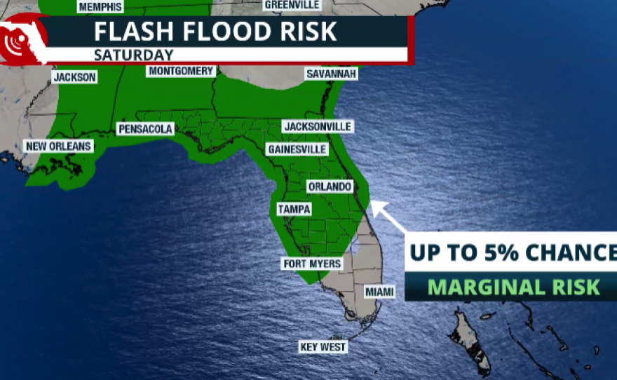
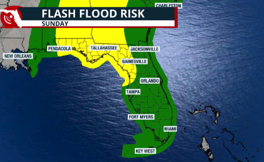
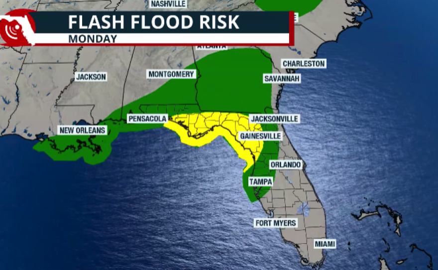
Across the Panhandle and western North Florida, there is a slight risk of flash flooding. Rainfall totals of 2 to 4 inches are possible, with isolated amounts approaching 5 inches. Keep in mind that this rainfall may not fall directly over official weather stations, so it may not significantly reduce the year-to-date rainfall deficits. Nevertheless, any rainfall will be beneficial as much of the state continues to deal with drought conditions.

The slight risk for flash flooding will remain in place across the Panhandle and Big Bend on Sunday, while a marginal risk expands into the Tampa Bay area. Forecast rainfall through the next five days continues to indicate the highest totals across the southern Panhandle and areas just north of Tampa, where more than 5 inches of rain could fall. Isolated locations may receive close to 8 inches.
Although showers and thunderstorms will generally move from west to east across Central and Northeast Florida, the sea breezes could cause storms to slow down, drift back eastward, and even redevelop over the same locations before moving offshore into the Atlantic. Rainfall totals between 1 and 3 inches are possible, although many areas will likely end up on the lower end of that range. Central Florida is expected to see more widespread shower and thunderstorm activity on Sunday than on Saturday. A drier pattern is expected to return next week, and with increasing sunshine, temperatures will climb back into the lower 90s.

South Florida is another area that could receive significant rainfall, especially south of Lake Okeechobee across the interior, the Everglades, and possibly extending into Palm Beach County and northern Broward County. Some locations could receive between 2 and 4 inches of rain, with isolated totals exceeding 5 inches during the next five days. Miami could receive around 2 inches over the same period.

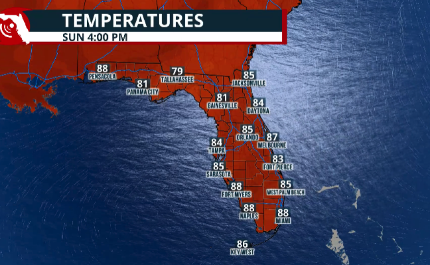

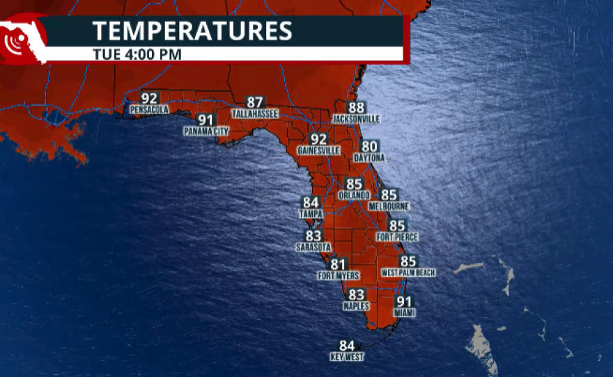
Although there will be daily chances for afternoon thunderstorms across Southeast Florida, the highest rainfall coverage is expected to arrive on Tuesday afternoon, when around 70% of the region has a chance of showers and thunderstorms.
Not only does Southeast Florida need the rainfall, but the increased cloud cover and thunderstorm activity should also help keep temperatures somewhat lower, with highs remaining in the lower 90s. South Florida endured excruciating heat last week, with multiple days under Heat Advisories as peak heat index values reached as high as 103°F.


