-
 Some showers over Central and Northeast Florida, while the warmer temperatures and sunshine stay over South Florida
 -
 This year was Florida's 84th coldest winter in recorded history, but it was also the 48th warmest.
 -
 Below-average temperatures will continue, with a freezing Tuesday night for the Panhandle and North Florida. Low cool afternoons could set new records.
 -
 Get ready to peel-off layers! We will bounce back to slightly above-average temperatures
 -
 February’s volatile weather patterns bring dramatic temperature swings across the Southeast, but particularly Florida. Digital meteorologist Leslie Hudson explains why this time of year remains one of winter’s most unpredictable transitions.
 -
 Late last month, record-low temperatures cooled down the waters of the Gulf and the Atlantic significantly, causing almost 800 sea turtles to wash ashore across Florida's beaches.
 -
 An unusually brutal blast of cold air from during the end of January and early February pushed temperatures down into record territory, causing widespread stress to plants.
 -
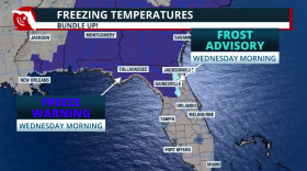
 The National Weather Service has issued an extreme cold watch for coastal Palm Beach County and a freeze watch for Miami-Dade and Broward counties.
 -
 Florida won't be getting hit with massive blankets of snow and ice like the rest of the U.S., but even frosty windshields and a few flurries can feel like Antarctica to people with permanent sandal tans.
 -
 The extensive winter storm brewing over the Rockies and Plains will impact millions over the weekend. Florida will be spared from winter precipitation, but not from the cold.
 -
 During the colder months, the National Weather Service can issue a range of alerts across Florida, from Frost Advisories to Extreme Cold Warnings, to help protect people, pets, plants and property.
 -
 With temperatures dropping in parts of South Florida this week starting Tuesday night, local officials activated their cold weather emergency plans. The National Weather Service said a cold front moving through the region Tuesday will bring in cooler air overnight.
© 2026 WLRN
Play Live Radio
Next Up:
0:00
0:00
Available On Air Stations


