

NOAA
Forecasters expect 8 to 14 storms will form in the Atlantic between June 1 and November 30. But the danger is more serious than the numbers suggest.
Understanding hurricanes: What you need to know


Find your shelter, evacuation zones and additional emergency information in the county you live in:
What you need to prepare


Hurricane Coverage
-
 As a warming planet generates more monster hurricanes that can rapidly intensify, researchers are whipping up winds and waves in a giant tank on Virginia Key to improve building designs and better forecasts.
 -
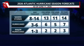 Colorado State lowers its 2026 Hurricane Season forecast due to a strong El Niño developing during the season. What does this mean?
 -
 In Florida, the forecast cone is only part of the story. Hurricane impacts can extend far beyond the center track — reaching inland through wind, flooding, and tornadoes.
 -
 Anyone who has been through a flood or hurricane knows the scene: waterlogged furniture piled on curbs, gutted homes with mold creeping up the walls, families displaced for months. But the recovery isn’t the same for everyone.
 -
 The National Oceanic and Atmospheric Administration said a looming El Niño weather pattern could help produce a below average season, but warned uncertainty about the forecast put the odds for a slow season at just 55%.
 -
 Insurance is supposed to soften the blow when homes burn or flood. With some preparation, you can better your odds of a smoother recovery if disaster strikes.
 -
 Every year, Americans rely on accurate forecasts when hurricanes might be developing to know when to stock up on supplies, prepare for power outages or evacuate. Those forecasts have improved dramatically in recent decades, but the improvements can’t be taken for granted.
 -
 During its annual storm drill, Florida Power & Light practiced rapid response for a mock Category 2 hurricane to keep customers in power during an extreme storm.
 -
 Clear skies can be misleading. In Florida, some of the most dangerous hurricane hazards begin after the storm—during cleanup, return, and recovery.
 -
 During storm season focusing on protection during the storm is mission critical. And in Florida, that can mean wind, water, and tornadoes all unfolding at the same time.


