-
 Hurricane Simon is still pounding Mexico's Pacific coast as it remains offshore. Authorities said Monday that five people have died in Mexico due to the hurricane and the remnants of Tropical Storm Rachel. Rachel caused street flooding and other damage in Mexico's Baja California state. Four people died after Rachel swept through over the weekend and at least six were missing.
 -
 Even with this latest activity in the Gulf, it's been a quiet Atlantic hurricane season so far, which is typical for the El Niño climate pattern we're in right now.
 -
 African tropical waves can take their sweet time traveling toward the Americas. But, on average, how long?
 -
 Tropical Storm Cristobal formed Wednesday over the North Atlantic, but the cyclone is expected to dissipate by the end of the workweek.
 -
 In an update Thursday, the National Oceanic and Atmospheric Administration said a strong El Niño will continue to help weaken storms.
 -
 Saharan dust and wind shear are keeping things quieter in the Gulf, but an ocean scientist says, "it only takes one in the wrong place."
 -
 The Peninsula had drier-than-usual conditions as Bertha was west of the state. The wind also left less hot afternoons across the western portion of the Peninsula, but as we wave goodbye to Bertha, rain and heat return to Florida. Let's look at this week's forecast.
 -
 Tropical Storm Bertha is producing dangerous surf and life-threatening rip currents for beaches along Florida's Panhandle.
 -
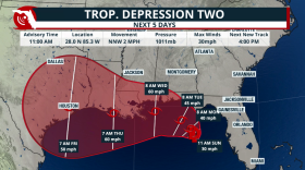 Tropical Depression 2 is set to become Tropical Storm Bertha as it travels mainly due west during the next few days. Gulf waters are warm and could strengthen this system if it stays well away from the Gulf Coast.
 -
 Rounds of heavy rain will impact parts of Central and North Florida due to a potential tropical system. Mixed signals on where it could go and intensity.
 -
 The remnants of a cold front could leave enough energy behind over the western Atlantic to ignite tropical storm activity east of Florida. What are the chances of this system developing, and where could it go?
 -
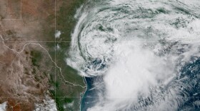 A disorganized cluster of storms that had been plaguing the Gulf Coast for days came together to form Tropical Storm Arthur on Wednesday — the first tropical cyclone of the season in the Atlantic basin.

© 2026 WLRN
Play Live Radio
Next Up:
0:00
0:00
Available On Air Stations


